![]()
Jump to
Back to Jump
![]()
Directions to the :William Brown boathouse
- 620 Lowell Street, Methuen.(Use this address for you GPS.)
- Take I-93 North or South to Exit 46 (Route 110/Route 113 toward Lawrence/Dracut)
- From I-93 North stay to the left on the ramp. Turn left at the traffic lights to Lowell Street/Route 110. Turn left at the first light to stay on Lowell Street/Route 110.
- From I-93 South stay to the left on the ramp. Go straight across at the traffic lights to Lowell Street/Route 110.
- Drive straight through the first light and continue on for 1.3 miles
- The boathouse is located on the left.
- Please be careful as the new roads confuse some drivers. Also please be careful to indicate early to turn into the boathouse so that people behind you know you are going to stop.
Back to Jump
![]()
Directions to Kent.
For Directions use the address :One Macedonia Road Kent, CT 06757
Go past the school, over the bridge turn right into Skiff Mountain Rd. The trailer and tent are usually in the field on the left, in front of their gym. The tent is close to the start, the finish is is a short drive away along Schaghticoke Rd. To reach the finish, drive back out on Skiff Mountain Road, straight across the 341 into the school grounds, through the grounds and out onto Schaghticoke Rd. Follow this road for about 3/4 mile. You will see cars parked in a field on the left at the finish line.
Back to Jump
![]()
Directions to Lake Quinsigamond for Andover Exeter Invitational
For the Andover/Exeter Invitational the boats will launch from the Donahue Rowing Center (DRC).
The race start will by the DRC.
The race finish line will be at the other end of the lake by the Regatta Point State Park.
The food tent will be at the DRC. Please follow the directions to the DRC.
You will probably be directed away from the parking lot just before the main DRC entrance by a local policeman.
Directions for Quinsigamond Rowing Ass. (Donahue Rowing Center) at Lake Quinsigamond, Worcester
Back to Jump
![]()
Directions to Salisbury.
Salisbury School is in Salisbury, Connecticut, at the southern edge of the Berkshires,
in the northwest corner of Connecticut.
251 Canaan Road, Salisbury, CT06068
Their boat house is on the opposite side of the main school(on the left hand side)
Turn right off the main road, follow the road, will turn into dirt road
one mile down a unpaved road, to Lake Washinee.
map: Click here to see the road off Main Street to Lake Washinee.
From Boston:
Take the Massachusetts Turnpike west to Exit 2 (Lee/Stockbridge).
You will pay a toll at the exit ramp and follow signs for Route 102 towards Stockbridge (left turn).
In Stockbridge, follow signs for Route 7 south toward Canaan (hard left).
In Canaan, at the stop light, take Route 44 west (right).
From Canaan, Salisbury School is 5 miles on your left.
Driving time is approximately 3 hours.
From New York City:
Take the Saw Mill River Parkway to Interstate 684 North.
Stay on I-684 until it becomes Route 22 North. Follow Route 22 to Millerton,
NY. At the first stop light, turn east on Route 44 (right).
Proceed 8 miles to campus on right side. Approximate driving time is 2 hours and 30 minutes.
Back to Jump
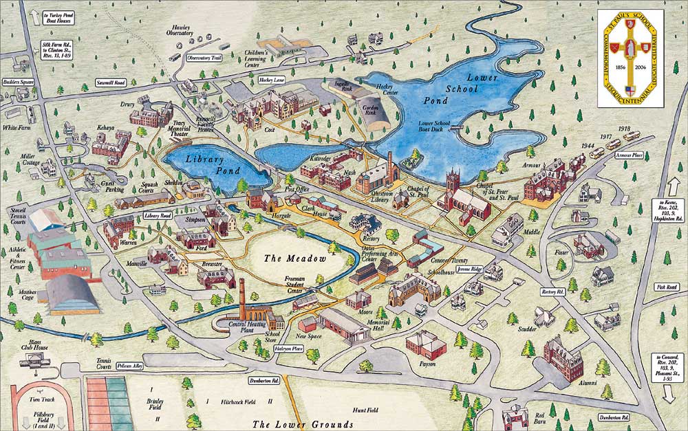
![]()
Directions to St Paul's Boathouse
use the address 391 Dunbarton Road, Concord, NH
Campus Map
From North or Concord via I-93
Take Exit 13 on I-93 to Route 3 North (Water Street)
Water street turns into Sth. Main St. Go through three sets of lights. At fourth light, turn left onto Pleasant Street (Route 202 West);
continue past Concord Hospital. St. Paul's School sign is on the left; turn left onto Dunbarton Road.
Continue on Dunbarton street through the school and on to the boathouse.
From South Via I-93 to I89 and then take Exit 2 on I-89 (Note: This is different from past years! do not follow your GPS)
At the end of the ramp turn right onto Clinton Street. Follow signs and take left onto Langley Parkway. Continue to end to intersection
of Pleasant Street (across from Concord Hospital). Turn left onto Pleasant Street. Go about a half mile and turn left at the St. Paul's
School sign onto Dunbarton Road. The boathouse is straight ahead on Dunbarton Rd, which turns to dirt one mile from Pleasant St., then
continues about 0.4 to the boathouse.
From the Massachusetts Turnpike
Take Exit 11a to Interstate 495 North. Follow to Massachusetts Route 3 North.
Follow Route 3 North which becomes Everett Turnpike at New Hampshire border.
Continue on Everett Turnpike to I-93 North. Follow I-93 North to I-89, just south of Concord.
Follow I-89 North to Exit 2, Clinton Street. * (Driving time in good weather from Boston is approximately 1.5 hours.)
Back to Jump
![]()
Directions to the Lowell Boathouse
FROM POINTS NORTH:
Follow Route 3 South in New Hampshire. Take exit 32 off of Route 3 at North Chelmsford.
You will immediately be on a rotary. Take your fourth right off of the rotary (there will be gas stations left and right).
Follow that straight through two sets of lights. At your third set of lights bear left through the fork.
Follow straight through two more sets of lights (Market Basket on left and White Hen Pantry on your right).
This will put you on the Rourke bridge which passes over the Merrimack river (i.e., TRR course).
Take a right off of the bridge. The boathouse is 200 meters down on the right.
FROM POINTS SOUTH:
Follow either I-495 North or 128 North (i.e., I-95 N). Take to Route 3 North.
Take exit 32 off of Route 3 at Rt.4 in Chelmsford. You will immediately be on a rotary.
Take your first right off of the rotary (there will be gas stations left and right).
Follow that straight through two sets of lights. At your third set of lights bear left through the fork.
Follow straight through two more sets of lights (Market Basket on left and White Hen Pantry on your right).
This will put you on the Rourke bridge which passes over the Merrimack river (i.e., TRR course).
Take a right off of the bridge. The boathouse is 200 meters down on the right.
FROM POINTS WEST:
Follow the Massachusetts State Turnpike headed East. Follow to either I-495 North or 128 North (i.e., I-95 North).
Follow to Route 3 North. Take exit 32 off of Route 3 at Rt. 4 in Chelmsford.
You will immediately be on a rotary. Take your first right off of the rotary (there will be gas stations left and right).
Follow that straight through two sets of lights. At your third set of lights bear left through the fork.
Follow straight through two more sets of lights (Market Basket on left and White Hen Pantry on your right).
This will put you on the Rourke bridge which passes over the Merrimack river (i.e., TRR course).
Take a right off of the bridge. The boathouse is 200 meters down on the right.
Back to Jump
![]()
Directions to NMH. map - Click on "satellite" button to see the road off Main Street to the river.
FROM EASTERN MASSACHUSETTS:
Take 495 south to Exit 29 (RT2 West). Follow Route 2 west (approx. 55 miles) to Route 63 north
Go north on Route 63 for approximately 8 miles to where Route 63 merges with Route 10
Turn left on Route 10 South
Drive 1.7 miles (you will cross over the Connecticut River)
Take the next left onto Main Road, to Gill Center.
Take the first left off Main Road (about ½ mile, a yellow gate) and drive down towards the river.
Go straight at the fork.
Back to Jump
![]()
Directions to Lake Quinsigamond
For the Interschols/NEIRA championship the boats will launch from the Regatta Point State Park. You should follow the directions
to the State park.
Neira regatta directions to Lake Quinsigamond, Worcester
This is a race course map for the college race at the same location.
For our race, our start will be the 500 meters marking.
Quinsigamond Rowing Ass. directions to Regatta Point State Park at Lake Quinsigamond, Worcester
Alternate Neira regatta directions to Lake Quinsigamond, Worcester
